Participate!
Join the discussion on the Demarcation of Catchment Management Areas in Botswana
Know more about the Study on Demarcation of Catchment Management Areas
consultant
client
financing/framework
Know more about the Study on Demarcation of Catchment Management Areas
consultant
client
financing/framework
consultant
client
financing/framework
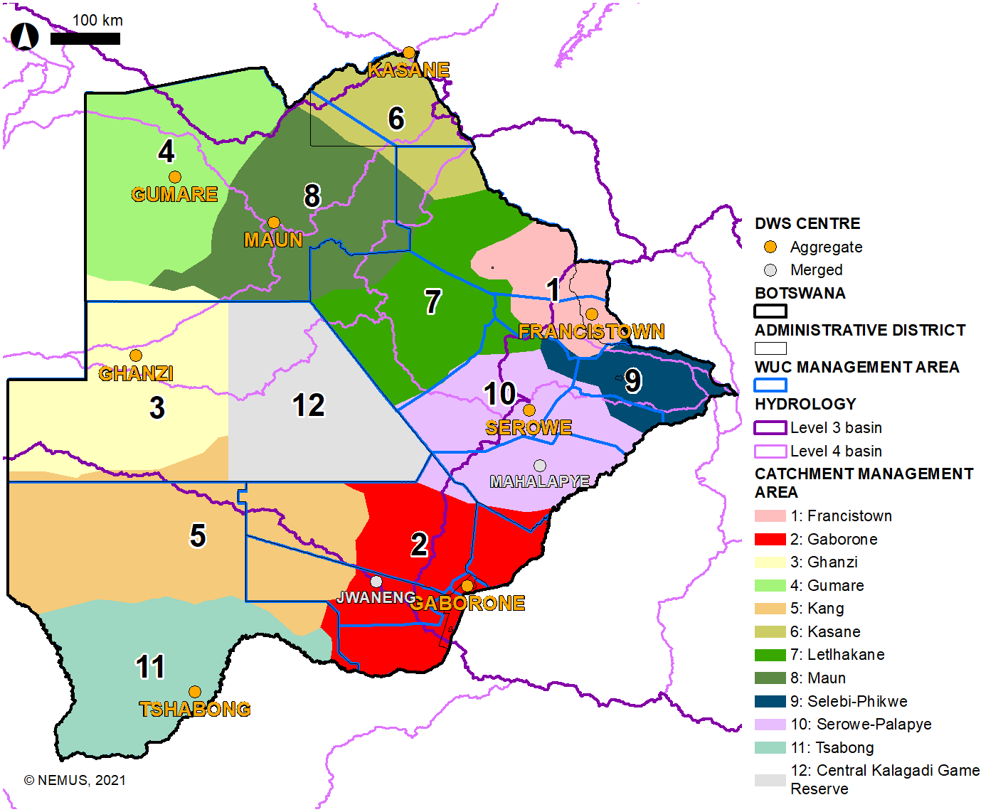
Botswana has scarce water resources, due to the country’s natural conditions, so water management is of extreme importance.
Critical issues on water management, in turn, differ throughout the country, according to the socio-economic and environmental context. While more than half of the territory is covered by the Kalahari Desert, namely the west, central and south-west areas, most of the available surface water resources are in the Okavango Delta and Chobe river systems located on the North. The population density and economic activities are also unevenly distributed, being mostly concentrated on the south-east region, and thus posing different regional challenges for water supply.
To address these different local water resources needs and conditions, Botswana National Water Policy of 2016 calls for the establishment of Catchment Management Committees (CMCs). This call is also made in more detail in the Integrated Water Resources Management and Water Efficiency (IWRM-WE) Plan (2013), which proposes that water should be managed at the lowest appropriate level, with a participatory and decentralised management approach.
However, there are no clearly set out catchment management areas in Botswana, so, first of all, it is necessary to officially conclude their demarcation. The physical delineation is to be based on mapping tools, public consultation, incorporation of lessons learned and finalization of agreed-upon defined areas, thus ensuring a participatory approach.
For the implementation of the catchment area management approach, the IWRM-WE Plan proposes two actions, also covered by the study on the demarcation of catchment management areas:
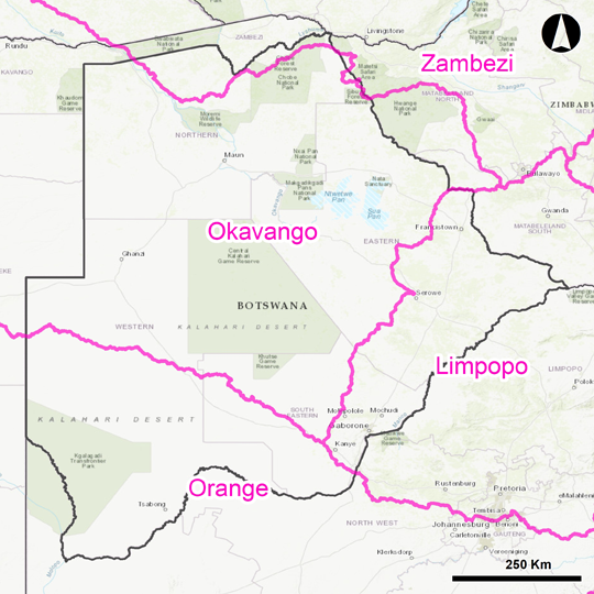
Botswana river basin boundaries
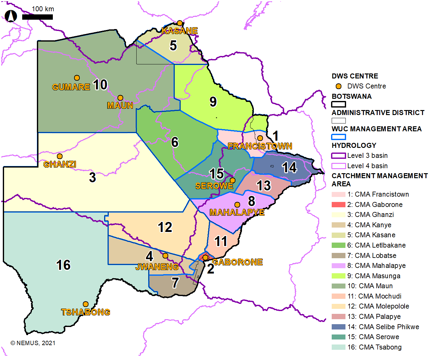
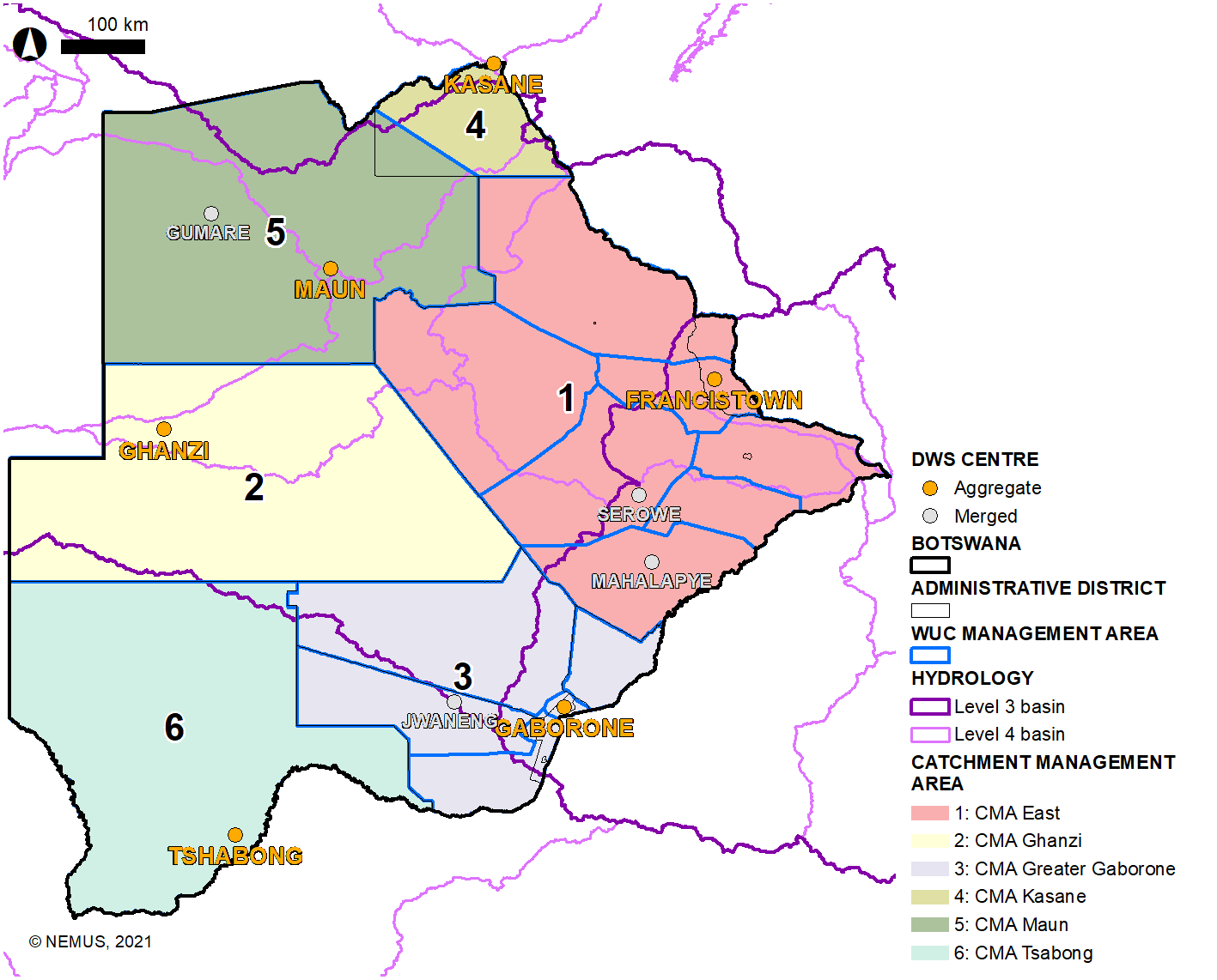
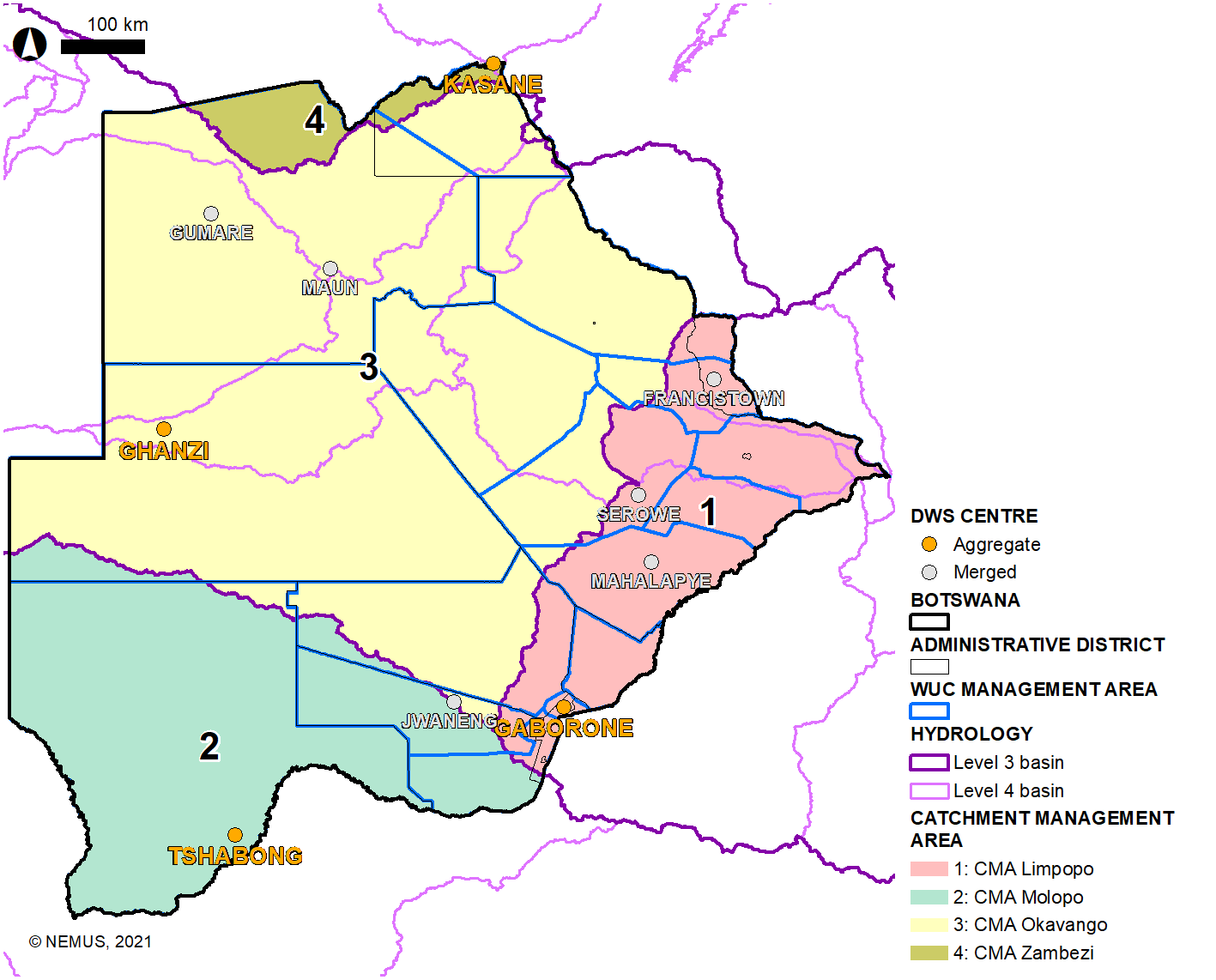
Four possible options for the demarcation of Catchment Management Areas (CMAs) in Botswana were proposed.
The proposed options were discussed in a country-wide institutional and community consultation that occur in eleven towns/ cities covering eight administrative districts. A final option will be defined in the final national workshop which will take place in the final phase of the project.
The proposed options are:
Demarcation of Catchment Management Areas (CMAs) based on the current zones.
Demarcation of Catchment Management Areas (CMAs) based on administrative Districts.
Demarcation of Catchment Management Areas (CMAs) based on river basin boundaries.
Demarcation of Catchment Management Areas (CMAs) based on spatial planning regions.
The first phase comprises baseline data collection and planning of the detailed work schedule and consultation programme, that is:
| Year | 2019 | 2020 | ||||||||||
|---|---|---|---|---|---|---|---|---|---|---|---|---|
| Month | Nov | Dec | Jan | Feb | Mar | Apr | May | Jun | Jul | Aug | Sep | Oct |
| Phase 1 | D-1 | |||||||||||
| Phase 2 | D-2, D-3 | |||||||||||
| Phase 3 | D-4 | |||||||||||
| Phase 4 | D-5 | |||||||||||
| Phase 5 | D-6 | |||||||||||
| Phase | Type | Target | Main objective |
|---|---|---|---|
| 3 | Surveys | Key stakeholders/ Institutions |
|
| 3 | Meeting/ Interview | Key stakeholders |
|
| 3 | Meeting | Kglota |
|
| 3 | Forum | Stakeholders and community |
|
| 5 | National Workshop | Stakeholders |
|
(PDF file | ~1.8 MB)
(PDF file | ~1.7 MB)
This phase involves detailed mapping and Geographic Information Systems work to create overlays of the numerous water resources, water supply, administrative and agricultural spatial areas, as well as other relevant information.
In this phase, the initially proposed demarcation of the spatial extent of the catchments will be made. The maps will utilize the available regionalization used in the water sector and shortlist 3-5 best overlays to be used during the community/stakeholder consultations.
The demarcation of catchment areas will consider the following criteria:
As a final result, the maps will use the available regionalization used in the water sector and shortlist 3-5 best overlays to be used during the community/stakeholder consultations.
The Overlaying of Maps (D-2) will be the second deliverable.
Another deliverable from this phase will be the Stakeholder Survey Templates (D-3). These are drafts of questionnaires and guiding principles to be used in the next community/stakeholder consultation exercises. The draft questionnaires and guiding principles will be prepared and discussed with the Client.
The survey templates are to be designed according to the specific consultation moments.
(PDF file | ~3.1 MB)
(PDF file | ~1.8 MB)
The overall objective of Phase 3 is to discuss the catchment areas management approaches through an extensive community/stakeholder consultation process, based on the outcomes from Phase 2. For this, the following specific tasks will be conducted:
(PDF file | ~1.5 MB)
The overall objective of Phase 4 will be the integration and consolidation of the results from previous phases. It will specifically aim at defining the structures and main guiding principles upon which catchment management strategy can be implemented. In this context, the following tasks are foreseen:
The objective of this phase is to disseminate and present the assignment results and, then, carry out the strategy validation with key stakeholders.
It involves two main components: